 Zane's Trace
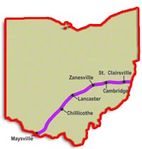
Zane's Trace was an early road, well, more like an early trail, in the Northwest Territory connecting Wheeling to Limbsville (present-day Maysville) Kentucky which was the northern terminus of a trail coming up from New Orleans.
Zane's Trace was a major trail in early Ohio until after the War of 1812. A "trace" is defined as a visible mark left by the passage of people or vehicle.
After the Revolutionary War Ebenezer Zane realized the need for an overland route because of the extremes and unreliable conditions that plagued Ohio River traffic. At that time, the Ohio River had a much different look than it does today with its numerous locks that stabilize river depths. In the early 1800s the Ohio River was prone to extreme flooding, ice flows and the appearance of massive sandbars that all contributed to the unreliability for regular river traffic.
In 1796, Ebenezer Zane petitioned Congress for permission to build a trail through the Ohio Territory that would be suitable for a horse and rider. In exchange for doing this the federal government would grant him land where the road crossed the Muskingum, Hockhocking (today is the Hocking River), and Scioto Rivers and pay for his surveying costs. The government agreed to the terms and required the trail to be open by January 1, 1797.
As soon as Congress authorized the construction of the road, Ebenezer Zane and his brother Jonathan, along with John McIntire (Ebenezer's brother-in-law) began clearing the land. They often followed existing Indian trails or paths that had also been used by former military expeditions. They did not survey the route, but instead took the path of least resistance, which often meant the trail took the longer route. It was widely believed that a trail would encourage increased trade and settlement in Ohio and further strengthen the federal government's influence on the territory.
When the trace was first completed, it was nothing more than a blazed trail that a rider with a packhorse could traverse. The first attempt at completing the trail were completed in the summer of 1797. Later, in 1803, the brand new Ohio Legislature authorized funds to widen and upgrade Zane's trail.
Ebenezer Zane was granted the rights to sell land at the river crossings and those developments became known as Zanesville, Lancaster and Chillicothe.
Many of the new settlers using the slightly improved route were Germans coming from Pennsylvania. The most widely area these new settlers stopped at was Lancaster which became a distinctively German community with store signs printed in both German and English.
By 1807 homesteaders had settled along almost every mile of Zane's Trace. Most of these homesteaders were farmers who sent most of their crops off to other markets by river using either the Muskingum River in Zanesville, or the Scioto River at Chillicothe, then south to the Ohio and from there to New Orleans.
 Like many of the roads used today, early roads were built over existing Indian trails whenever possible. Zane used these same Indian trails as well. He basically cut down trees to make the road that was really just a primitive path. When first completed, the road wasn't even accessible by wagon. It was so narrow and rough that travelers could only travel it either on foot or horseback.
Where the trace crossed larger streams and rivers, Zane was required by his contract with the federal government to build ferries at each of these river crossings. These ferry crossings often became towns, many of which suvived and grew. One such example is Cambridge Ohio.
When Zane reached Wills Creek, it was the first stream his trail had to cross that required a ferry. Soon after setting up the ferry service in the fall of 1797, settlers began to arrive and buy land that surrounded the ferry crossing. Another ferry crossing town was located at the mouth of the Licking River and came to be known as Zanesville, named after Ebenezer Zane.
Those who used Zanes Trace began referring to it by a number of names, including the Wheeling Road, the Wheeling-Limestone Road, or just the Limestone Road, rather than Zane's Trace. As with any road, businesses developed along the way to serve the needs of those traveling the road. This encouraged additional development. Ebenezer Zane founded Wheeling, and also helped settle Lancaster, Ohio.
Zane's Trace and the National Road shared the same route between Wheeling and Zanesville. Today, there is a portion of Zane's Trace between New Concord and Zanesville that can be driven in an automobile except for a section at the Zanesville Airport. The road is narrow and winding, and is an example of what the National Road and Route 40 were like before the modern era of road building that started in the 1930s. Surviving segments have been identified in Belmont, Guernsey and Muskingum Counties.
Ebenezer Zane
Ebenezer Zane was one of 6 children born to William Andrew Zane and his wife, Nancy Ann Nolan. He had four brothers, Silas (born 1745), Andrew (born 1749), Jonathan (born about 1750), and Isaac (born 1753), and one sister, Elizabeth "Betty" (born 1759). Ebenezer Zane married Elizabeth McCulloch.
 Zane headed west with his brothers Silas and Jonathan Zane from Moorefield and established Fort Fincastle, which was later renamed Fort Henry in 1769 in honor of the American patriot, Patrick Henry.
From 1777 to 1782, during the American Revolution, Zane and his brothers defended Fort Henry against Native American attacks. Zane's sister Elizabeth was celebrated for her courage during one of these Native American attacks: she ran out of the fortress walls to retrieve a badly needed keg of powder. There is a statue dedicated to Betty Zane in Martins Ferry.
Ebenezer Zane died in 1811 and is buried in Martins Ferry along with most of his family.